El Salvador is Central America’s smallest country and at the same time the most densely populated. The country is located along the Pacific coast and borders Honduras and Guatemala. The country’s capital is San Salvador and this is also the largest city. Other important cities are Santa Ana and San Miguel. In 2013, it was estimated that the country had a population of about 6.29 million. Before Europeans discovered and colonized El Salvador, the area was home to many different Mesoamerican civilizations. In 1525, Spain had conquered the area and made it part of New Spain. In 1821, El Salvador gained independence as part of the Central American Federation. When this federation was dissolved in 1841, El Salvador was independent for a short time before entering into a union with Honduras and Nicaragua that lasted until 1898.
Mer om El Salvador
During the 19th and 20th centuries, El Salvador had major political problems with coups and revolts. This also led to financial instability. It all culminated in the civil war that took place between 1979-1992 and was fought between a military-led government and a coalition of guerrilla groups. It all ended with an agreement that gave a constitutional republic with several parties and that is still the case today. El Salvador’s economy has historically been dominated by agriculture. During the early 20th century, coffee was the largest export item.
Geography and climate
El Salvador is the smallest country in continental America and has a total area of about 21,040 km². The country has several rivers, the largest of which is Lempa, which flows through Honduras and then via El Salvador to the Pacific Ocean. This river is large enough for ships to travel on it. The country also has lakes formed in volcanic craters and there are also artificial lakes that have been added as a result of dam projects. The main natural resources are petroleum, arable land, hydropower and geothermal energy.
According to bridgat.com, the country has a tropical climate on the coast and in the highlands the climate is temperate. The rainy season is between May and October and then you are often hit by severe storms.
Natural disasters
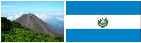
El Salvador’s location on the Pacific Ocean means that you are often hit by severe weather with rainstorms as well as extreme drought. It is believed that the harsh weather has worsened due to the effects of El Niño and La Niña. Due to the fact that so much forest has been felled that has led to soil erosion, landslides are also common. You also get storms coming in from the Caribbean and since the 1990s, the frequency of storms has only increased. The country is located by the Pacific Ocean aging and is therefore exposed to a lot of tectonic activity. You often get earthquakes and also have a lot of volcanic activity in the country. In 2005, the Santa Ana volcano had an eruption that led to nearby villages being hit by ash and rocks. The outbreak caused a lot of damage materially, but only two people died from it.